


As you develop more hiking and outdoor skills, weather forecasting can play an important role in deciding what to do on your day(s) off of work. Weather is always changing and when you get good at weather forecasting you can pivot weekend plans between mountaineering or rock climbing or backpacking or backcountry skiing.
I’ve been rescued due to high volumes of rain while being soaked through all my layers, woke up to snow at our campsite in September, holding up tent walls all night through a 60 mph wind storm, and hunkering in my tent as it hailed with thunderstorms outside.
It’s funny looking back. In the evenings, I grew up with my dad always watching the weather station. He works labor jobs and needs to know when it is raining and snowing. We always used to joke and count the pregnant weather ladies. Little did I know this nightly routine of watching the weather forecast would play a huge part in my outdoor planning now.
I’m becoming a weather nerd. Though I never took a meteorology class in school, over the years, I’ve been perfecting the best tools depending on my outdoor recreation on making a go/no-go decision on a trip and want to share what I have learned with you.
Note: This post contains affiliate links. Meaning if you click and buy some of the products linked in this post, I may earn a small percentage at no extra cost to you.
Start with a high-level forecast
I suggest using one national or international website that forecasts, so you can become familiar with how accurate the reports hold to the actual weather. Though, when starting out, it may be best to research the most accurate ones for the region you live or try out a few and see which one you like best.
Predicted high and low temperatures
Once you find a general weather report that includes the high and low temperatures, continue to monitor the weather patterns within 5 to 7 days before your trip, including sky coverage (sunny, partly cloudy, or percentage of rain). Many sites can help you pick an accurate location on a map where you can select the forecast area if you’re heading to the mountains.
Monitoring the weather in advance will help you understand the weather fronts, or storm cycles, moving through the area.

Radar and satellite forecasts
Time to make a decision! Head to your favorite website and check the weather. Now is the time to drill down on the radar to see the movements of the cloud cover and precipitation.
Tip: I use radar for a quick decision point and use it to see a view of the best weather within driving distance. Then, I can make a decision on my plans based on the localized weather.
Hourly weather forecast
After getting a high-level look at the radar and satellite forecasts, understand what the radar is showing. An hourly weather forecast provides details for when you’ll be outside. Below, you can dive into different weather forecasts to help make the decision.
Tip: Take screenshots of the weather detail if you will be out of cell phone service for a few days.
Consider making mental notes on how you feel on “bad” weather days. What high and low temperatures are you uncomfortable with? What wind speeds knock you off your feet or make you frustrated? Gusts of wind at 70 mph usually knocks you off your feet, but anything greater than 50 mph definitely impacts balance, especially on uneven ground.

Storm brewing in the distance.
Temperatures
Here you can get a better look at the high’s and low’s and what time to be ready to add on that extra puffy jacket. Some sites graph the temperature fluctuations to show the times when it will be warmest or coldest throughout the day. Take a mini keychain thermometer to help evaluate if the forecast was accurate.
Wind forecast
Not only do I pay attention to the temperatures, but I also look at the wind speeds (and gusts). After a few years in the outdoors, I know how I perform in high wind speeds (good and bad) versus low wind speeds. Anything above 20 mph in alpine terrain with low temperatures can be frustrating. I normally will still go if the winds are less than 40 mph unless the trail stays along a ridge (understand the terrain). Knowing the windchill will come in handy when you start to pack.

On the summit of Japan’s Mount Fuji after hiking in a cloud with relentless 40 mph winds.
Precipitation, sky cover, rain/snow by volume
Precipitation and sky cover may not be enough to cancel your plans. It’s common to have days in the Pacific Northwest with high percentage of sky cover with 20% precipitation or traces of rainfall. Anything under 50% chance has me out the door most days unless the rainfall volume is more than I’m willing to endure.

Now you have a base on what the weather may look like, but it’s time to add another element: Elevation.
Factor in elevation
Depending on your adventure, you may start at a low elevation and then climb a few thousand feet. Weather changes due to the adiabatic lapse rate, or the rate that temperature decreases with increasing altitude in conditions of thermal equilibrium.
I like to take screenshots of the graph for the trailhead, my campsite, and my highest elevation to ensure I’m properly prepared for the weather and know what to pack. Some sites are better than others for targeting various elevations.
Not only does elevation come into play but the terrain as well. Are you hiking on a mountain crest, or where the weather tends to converge? You may want to pay extra attention to weather patterns on both side of the mountain ridges (or crests).
Best outdoor weather forecasting tools and how to use them
With the invention of mobile apps and other aggregate weather sites, the list is endless. Below are some of my favorite tools for weather.
Weather forecasting websites
I already mentioned weather.gov (aka the National Oceanic and Atmospheric Administration) as being my preferred website, but you can find one that works for you. Here are a few examples:
NOAA – Weather.gov
The adjustable forecast area map helps me find my planned location to dig into the forecast to help make a decision to go. The hourly weather forecast graph and forecast discussion help me interpret and learn the upcoming and past weather patterns to make informed plans.
The Hourly Weather Forecast graphs the 48-hour forecast for temperature (including windchill), wind (and wind gusts), precipitation (paired with humidity and sky cover), rain or snow levels), and thunder potential. The top left corner reminds you of the elevation and GPS coordinates the forecast covers.
Chance of rain in the forecast? The chart breaks down how much rainfall (or snow) by volume you can expect. Anything under 0.1 inches of rain shouldn’t be significant enough to cancel your plans. Modify your plans if exposed to the weather based on the weather windows depicted.
NOAA is 70% accurate whereas most other commercial sites and European models are over 80% accurate.

Mountain Forecast
With a brief 0-3 or 3-6 weather preview, use Mountain Forecast for another visual of weather elements, including the option to toggle between elevation levels to see the temperatures for a better preview of freezing levels, or the level where the temperatures reach freezing (32-degrees Fahrenheit or 0-degrees Celsius).

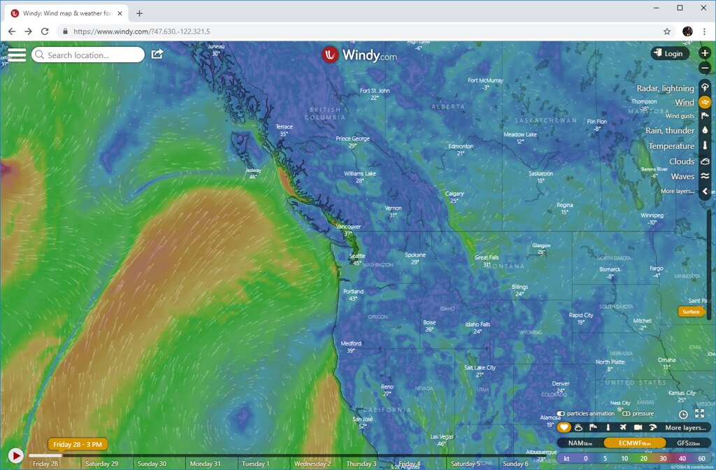
Windy.com
Windy.com isn’t just for wind. Cross reference and compare different models using this site. They even state the strengths and weaknesses of each model. Windy.com came in handy when I was backpacking in Norway.
Best apps
Now, I have an Android phone, and I always go on the web browser before I go offline one last time to look up the weather on my preferred weather site. Though, some people do prefer applications to websites.
Radar apps
Android: The one I use the most is Flowx: Weather Map Forecast (previously known as WeatherBomb) for an interactive moving radar of the area that includes cloud cover, rain, and wind.
iOS: I don’t actually own an iPhone, but my research suggests a paid-for app called RadarScope provides good visuals of the radar (also available on Android).
Avalanche forecasts
Available on both Android and iOS, use Avalanche Forecasts mobile app in the winter months. Avalanches can be triggered by many factors, including hikers and skiers. Be sure if you’re traveling on mountain slopes to know the risk before going or sign up for an American Institute for Avalanche Research and Education (AIARE) class to learn more. My favorite website for the Pacific Northwest is NWAC.us which details various forecasts for above treeline, near treeline, and below treeline.
You can find your regional avalanche center at avalanche.org.

Other resources
Depending on your objective, I recommend checking with the local ranger station before you adventure in the national park or forest.
Why? 1. You can ask questions about your plans and the rangers most likely are very familiar with current conditions, like a river washing out a road, wildlife, or trail closures. 2. Ranger stations normally have the weather reports printed and hung for people to reference before you go. Some, if they have time, will even make sure you packed the necessary gear and clothing just in case the weather turns.